Introduction
to calculating the זמנים
הנראים according to
your coordinates
(Last revised: כ"ה כסליו
תשע"ז, 12/25/16)
Until now, the basis for the calculation of זמנים הנראים on this site was dependent on letting the server find a vantage point within a database of high vantage places within a chosen search radius of the entered coordinates or place name. Although that method has clear benefits in terms of user friendliness, it is necessarily limited to major Jewish centers in the world. It was therefore always the intention of the author to design a website to allow for determining הנראים זמנים at any coordinate. Thanks to recent advances in technology and to the release of accurate world-wide terrain data, such a website became feasible. These calculations are supported for most of the world (from S60 to N74) using different data sources (see details below in Part II of this Introduction).
This introduction is divided into two parts. Part I brings the sources in the גמרא and פוסקים for using the nearby high point for calculating the visible sunrise and sunset for adjoining lower places. The second part is a step by step manual of how to use this utility on our website. Users who prefer to follow the instructions without delving into the הלכה and its basis in the גמרא and פוסקים can skip directly to Part II.
PART I: The sources in
the גמרא and פוסקים and their interpretation
Why use the הנראים זמנים of sunrise and sunset for תפילה purposes and not the זמנים
אסטרונומיים, and why they are determined from the
highest place in the vicinity.
In the משנה (ברכות, פרק א, משנה ב) it is brought down: מאימתי קורין את שמע בשחרית...עד הנץ החמה.... The גמרא ירושלמי on that משנה clarifies when the time of נץ actually is, i.e.
"עד
הנץ החמח", רבי
זבדיה בריה
דרבי יעקב בשם
רבי יונה כדי שתהא
החמה מטפטפת
על ראשי ההרים
The רבינו יונה on ברכות determined that the above opinion in the ירושלמי is the הלכה, viz.,
שנץ החמה נקרא מעת שמתחלת החמה לזרוח בראשי ההרים.
The ביאור הלכה( 58,1) wrote that this is in fact the opinion of the בעלי תוסופות, and it is the basis of the sunrise time that was discerned by the נברשת in the בית המקדש יומא לז)). In a previous article, I described how the נברשת definitely overlooked a mountainous horizon and therefore the time of sunrise for the נברשת was also dependent on when the sun was seen over those near obstructions.
Is this the case only for sunrise, or also for sunset? The גמרא in ברכות (29b) clarifies that the preferred time for תפילת שחרית and מנחה are similarly defined, i.e.
דא"ר חייא א"ר יוחנן מצווה להתפלל עם דמדומי חמה וא"ר זירא מאי קראה ייראוך עם שמש ולפני ירח דור דורים
רש"י wrote on this גמרא:
"עם
דמדומי חמה"
תפילת יוצר עם
הנץ החמה
ותפילת מנחה
עם שקיעת
החמה, "ייראוך
עם שמש" זו
תפילת יוצר,
"ולפני ירח"
זו מנחה
It then follows logically that if
the preferred time for שחרית is at sunrise as the first light appears
on the mountain tops, the analogous case should apply for מנחה )i.e., the
preferred time for מנחה is when the sun is reddened as it sets, as
seen from the mountain tops).
This preference is also implied in the גמרא
שבת (118b)
where it is written:
א"ר
יוסי יהא חלקי
ממתפללים עם
דמדומי חמה, א"ר
יוחנן מצווה
להתפלל עם
דמדומי חמה, א"ר
זירא מאי קרא
ייראוך עם שמש
ולפני ירח דור
דורים
רש"י writes there:
"דמדומי
חמה" כשהיא
אדומה שחרית
אחרי הנצה מיד
היא אדומה
וערבית סמוך
לשקיעתה, "עם
שמש" עם
זריחתה,
"ולפני ירח"
קודם אור הירח
בעוד השמש לא
שקעה
This הלכה must also apply to
people in low lying places who can’t observe דמדומי
חמה (a
reddened sun can only be observed several minutes before the מישור sunset, during the time that the sun is
blocked by mountains west of low areas).
How? Does the גמרא mean to say that they also fulfill the מצווה by waiting until דמדומי
חמה is seen on
the mountain tops nearby (i.e., when the sun is מטפטפת
על ראשי הרים)?
In any case, the הלכה is that we don’t wait עם
דמדומי חמה to pray מנחה due to a חשש that if one would wait until that time to pray,
it may eventually lead to praying after שקיעה, i.e.,
לייטי
עלה במערבא
אמאן דמצלי עם
דמדומי חמה מאי
טעמא דלמא
מיטרפא ליה
שעתא
רש"י
(שם) explains:
"לייטי
במערבא" על מי
ששהה תפילת
המנחה עד דמדומי
חמה שמא תטרף
לו השעה ע"י
אונס ועבר
הזמן
This seems to answer our
question, i.e., we know from רש"י in שבת that דמדומי
חמה
is right before sunset. And it
must be שכיח in order to warrant that"לייטי
במערבא" . Therefore, דמדומי
חמה must
also apply to people in low-lying areas in the manner described above, ודו"ק.
In my opinion, we actually find
an application of this הלכה in the גמרא in שבת (118b) in the name of
ר' יוסי right after the מימרא of דמדומי
חמה that we
brought above, i.e.,
א"ר
יוסי יהא חלקי
ממתפללים עם
דמדומי חמה…א"ר
יוסי יהא חלקי
ממכניסי שבת
בטבריא וממוציאי
שבת בציפורי
י רש" writes there:
מפני
שהיא עמוקה
ומחשכת מבעוד
יום וסבורין שחשכה
וממוציאי שבת
בציפורי
שיושבת בראש
ההר ובעוד
שהחמה שוקעת נראית
שם אור גדול
ומאחרין לצאת.
There is no doubt that places
that see “אור
גדול”
during and after sunset will also encounter דמדומי
חמה before
sunset. Low-lying places will not. However, the מצווה, at least מעיקר
הגין,
is to pray עם
דמדומי חמה everywhere. It then follows that sunset of ציפורי (the mountain top)
must also determine the sunset time of טבריא (the valley), at
least מעיקר
הדין. This is in fact what רש"י is implying in his
explanation (above) of יהא
חלקי and is exactly what we deduced from רש"י in ברכות. We
can even say, according to explanation of רש"י, that there is no further חידוש in theמימרא of
רבי
יוסי beyond what he was מחדש in his מימרא of דמדומי
חמה. Of course, there is a נפקא מינאto the הלכה, and this is what רש"י meant in his פירוש.
Namely, even though we don’t wait to pray מנחה until דמדומי
חמה, we do
apply what we learned
from the סוגיה of דמדומי
חמה
were it is a סייג לחומרא.
That is, on מוצאי
שבת
we use the צה"כ of high places to determine the time of צאת
השבת for adjacent low areas blocked by very near
obstructions. I.e., we wait until the
adjacent high places no longer observe “אור
גדול”.
Is there proof מההלכה to our connection
between זמני
שקיעה of low areas to זמני
שקיעה
of adjacent high places as we deduced from ברכות and שבת? Indeed there is. Namely, רש"י’s interpretation of the סוגיה of “יהא
חלקי”
is used to determine the time of תפילת
מנחה
during the week for low-lying places blocked by near obstructions such as טבריא.
This comparison is brought down in the מ"א (או"ח 233, אות
ז) in the name of the דרכי
משה
(i.e., the רמ"א),
וז"ל
ד"מ מהרי"ל
היה מתפלל
מנחה בשעת
הדחק סמוך לצ"ה
ואמר אע"פ
שנראה בעיר
לילה מ"מ
עדיין יום הוא.
כמ"ש ר"י יהא
חלקי ממכניסי
שבת בטבריא
עכ"ל. וזהו
דווקא בעיר
שבתיה גבוהין
או יושבת בעמק.
We summarize that, מעיקר
הדין,
the sunset time for the mountain top, e.g., ציפורי, determines the sunset time (for prayer purposes)
in the valley. This must be true even
when there are even higher mountains in the west of the “high” places since
this is the almost universal case for ארץ
ישראל,
and was almost certainly the case of ציפורי.
Proof of this point is from the נברשת (יומא 37b) which was situated either inside the אולם on top of the doorway
to the היכל or on top of the בית
המקדש
(see my article on the נברשת
). The horizon of הר
הבית is blocked by higher mountains in the East, and even by
the nearby mountains of הר
הזיתים (שם). Nevertheless since it
was the highest place vis a vis the inhabitants of Jerusalem at that time, it
determined the appropriate time for תפילת
שחרית,
and presumably also of sunset for מוצאי
שבת, for all
inhabitants of ירושלים according to the ריטב"א and the בעלי
תוסופות.
There is actually a רמז in the חומש to using the sunrise from the mountain
tops to fix the sunrise times for תפילה in the lower lying
adjacent areas. In the גמרא
ברכות
(7a) it is brought down how הקב"ה gets angry for one
moment of each day. The גמרא then proceeds to clarify which moment that
is, i.e.:
תנא
משמיה דר'
מאיר בשעה
שהחמה זורחת
וכל מלכי מזרח
ומערב מניחים
כתריהם
בראשיהם
ומשתחווים
לחמה מיד כועס
הקב"ה
The גמרא further relates that only בלעם
הרשע knew how to discern that moment, i.e.,
ואין כל
בריה יכולה
לכוין אותה
שעה חוץ מבלעם
הרשע דכתיב
(במדבר כ"ג)
ביה ויודע דעת
עליון...שהיה
יודע לכוין
אותה שעה
שהקב"ה כועס
בה והיינו
דאמר להו נביא
לישראל (מיכה ו') עמי
זכר נא מה יעץ
בלק מלך מואב
וגו', מאי (מיכה
ו') למען דעת
צדקות ה' א"ר
אלעזר אמר להם
הקב"ה לישראל
דעו כמה צדקות
עשיתי עמכם
שלא כעסתי
בימי בלעם
הרשע שאלמלי
כעסתי לא
נשתייר
משונאיהם של
ישראל שריד
ופליט והיינו
דקא"ל בלעם
לבלק (במדבר
כ"ג) מה אקב לא
קבה אל ומה
אזעם לא זעם ה'
מלמד שכל אותן
הימים לא זעם.
Obviously, the sunrise time from
the ראש
הפסגע
whereבלעם and בלק were (במדבר
כ"ג) was
different from the sunrise seen below in מחנה
ישראל. Nevertheless, בלעם had only to decipher
the moment of sunrise on top of hill, and it would have been the identical רגע that הקב"ה would have been angry vis a vis the
inhabitants of ישראל מחנה below.
Another reason for connecting
the זמנים on the mountain tops
to the זמנים below the mountain
tops
The מאירי in ברכות (9b) explained why חז"ל established sunrise
as the a priori time to pray שחרית.
The מאירי wrote that it was in
order to mitigate the damage caused by the sun worship of the גוים from the mountain
tops. This תקנה clearly applied to
every place in the world at its own sunrise time since the גמרא mentions that כל
מלכי מזרח
ומערב
were involved. The נביא attests to this fact in numerous places in
נ"ך, e.g. מלכים א' (14, 23),
ויבנו
גם המה להם
במות ומצבות
ואשרים על כל
גבעה גבוהה
ותחת כל עץ
רענן
The מימרא ofחז"ל
(סנהדרין 47b), אלהיהם על
ההרים ולא
ההרים אלהיהם,
also testifies to this fact.
Even another reason….
We have already mentioned two of the main reasons for the preference of
using the הנראים
זמנים
for sunrise and sunset for prayer purposes, i.e.
1.
חז"ל
established that we should pray
at the time that the kings began their sun worship in order to mitigate the
anger of הקב"ה.
2.
To fulfill the verse:
דא"ר
חייא א"ר
יוחנן מצווה
להתפלל עם
דמדומי חמה
וא"ר זירא מאי
קראה ייראוך
עם שמש ולפני
ירח דור דורים
There is also a third
reason. The rabbis, of blessed memory,
tell us in tractate מגילה (20b) that the מצוות that are done during
the day, are permitted to be done, a priori, only after the sunrise even though
the day begins at dawn. רש"י explains that this is
so we should have no doubt that the night has passed. The ר"ן explains further that not everyone knows how to distinguish the
dawn from the night. We therefore wait until the visible sunrise, for only at
that time is it clear to everyone that the night has passed. The משנה
ברורה
(in Section 588(2) ) clearly implies that this was the intention of the ר"ן . The משנה
ברורה,
when discussing the proper time to blow shofar, first brings down the ר"ן (לעיל) and then quotes the פמ"ג that one doesn't have
to wait to blow shofar until the entire sun is visible, rather it is sufficient
to wait until only the very first part of the sun is visible. Obviously, the פמ"ג is referring to a
visible sun, and so is the משנה
ברורה. It is often asked, that if that is the case,
then inhabitants of עשתרות
קרניים would need to wait until midday to
commence מצוות
היום. However, we have already answered this
question above. Namely, the sunrise time
from the nearest high place determines the sunrise time for עשתרות
קרניים also. An example of this
is עיר דוד, located in the עמק
קידרון. The visible sunrise
time for that place in parts of the year is almost an hour later than the
sunrise on הר הבית.
Nevertheless, the sunrise for the בית
המקדש
determined the time of sunrise for תפילה
כוותיקין even for the inhabitants in עיר דוד according to the
opinions of most of the ראשונים (as we explained
above when briefly discussing the סוגיה of the נברשת (יומה 37b)(.
Summary
It is preferred to use the visible
sunrise and sunset days for prayer purposes whenever possible. The sunrise and
sunset times for even low places are determined by the sunrise and, מעיקר
הדין,
the sunset times of an adjacent high place.
How far is still considered “adjacent”?
Apparently, it is no less than the distance from טבריא to ציפורי.
The גליון
הש"ס in
the name of the שו"ת
הר"י מיגאש wrote that they were within a תחום
שבת (i.e.,
2000 אמות, or about 1.2 km).
In
conclusion, when using the “Visible times at your coordinates” webpage to
calculate the visible sunrise and sunset, it is imperative to find a high
place, if possible, within a תחום
שבת of any
specific place. One should not use the
times calculated from vantage points that are blocked by very near
obstructions. The appropriate strategy
to accomplishing this goal will be detailed, אע"ה, below.
PART II: Step by step instructions for using the Chai Tables
“Visible times at your coordinates” webpage
The 1 arc second
(approximately 30 meter) DTM for ארץ
ישראל
and the World
The Digital Terrain Model (DTM)
used for calculations in this webpage is a 1 arc second (approximately 30
meter) grid of heights based on 1 x 1 degree tiles. For ארץ
ישראל,
the tiles used are derived from the 25 m DTM of Israel. For North America, NED 1 arc second tiles are
used. (N.b., the original 8 byte
NED data has been converted to a 4 byte format, which was deemed to be of
sufficient accuracy for these calculations.) While the coordinate system used in the 25 meter DTM of
Israel is the Old ITM (Israel Transverse Mercator) coordinate system based on
the Clark 1880 geoid, the 1 arc second DTM uses a geographic coordinate system
of latitude and longitude based on the WGS84 geoid. Since translation between the two coordinate
systems is not completely accurate, the total error associated with these
calculations has increased in comparison to similar calculations using the 25 m
DTM. This diminished accuracy of the 1
arc second DTM also applies for regions outside ארץ
ישראל. Although the longitude grid spacing of the 1
arc second DTM varies as a function of latitude (it is approximately 30 meters
at 16 degrees North latitude and only 13 meters at 65 degrees North latitude),
nevertheless the grid spacing in latitude is virtually constant, i.e., approximately
30 meters. Therefore a cushion of 20
seconds was chosen for the calculations based on the anticipated scatter in the
sunrise/sunset times from atmospheric effects, i.e., 15 seconds, plus the
effect of heightened inaccuracy in the DTM versus the 25 meter DTM of ארץ
ישראל. [A constant 15 seconds cushion is used for
calculations using the 25 m DTM, based on the scatter in sunrise times seen in
actual observations (see here
for more details)]. Likewise,
obstructions closer than 6 km are deemed “near” obstructions and are marked in
green. (A constant 5 km value is used
for defining “near” obstructions for calculations based on the 25 m DTM.) A constant 30 seconds cushion and a near
mountain limit of 10 km is used for calculations in England due to the lower
precision for the DTM’s source available for that region (50 meter Ordinance
Survey of the UK interpolated to a 1 arc second grid). The data source for Western Europe is the
EU-DEM which is based to the most part on 1 arc second SRTM satellite
data. The data source for most of the
rest of the world (from S60 to N60 latitude) is the SRTM 1 arc second satellite
data. As all satellite data, there are
artifacts due to buildings and foliage.
Therefore, one must be careful when interpreting results for populated
areas. Buildings can often mask themselves in this data as
"hills", and it might be necessary to ignore nearby
"terrain" (see the discussion on parameter "1f"
below). To determine if artifacts are indeed contributing to the
calculated horizon, one should view the near horizon using the map tools in the
"Geofinder" webpage. (An excellent and thorough treatment of
satellite artifacts and how they can be treated was written by the Australian
government geoscience division. The link is here.)
How to use this tool in
calculating the visible sunrise and sunset times for your
After picking “Visible times at your
coordinates” instead of a “country”, you are directed to the main webpage used
for calculating the זמנים.
However, before you calculate any זמנים, you must enter coordinates. It is preferable to use the “Chai Tables Geofinder” utility to find coordinates in order that sign
errors concerning the longitude entry are not made. Use the “Geofinder”
utility by pushing the “Chai Tables Geofinder”
button.
1. After pushing the “Geofinder” button, you are directed to the “Geofinder” webpage.
2. Pan and zoom on the Google map and then click to pick the desired place.
3.
Determine whether you are
on a hill top (for the reason, see Part I above) without very near obstructions
by viewing the desired horizon using the “View” buttons on the bottom of the
webpage. (You will be prompted to
install the Google Earth plugin. This
plugin does not work consistently on browsers other than Google’s
“Chrome”. We therefore advise using
Google’s “Chrome” browser whenever possible.
בדיעבד, when using Microsoft’s IE browser, it
sometimes helps to install the “ChromeFrame BHO”
plugin.)
4.
The Google Earth plugin has
been programmed in the “3D View” webpages to hover as close as possible to the
position and ground elevation you chose with the “Geofinder”. This facilitates a realistic simulation of
the western (for sunsets) or eastern (for sunrise) horizon view for an observer
on the ground. You can move beyond the
chosen point by either entering different coordinates next to “Fly Here”
button, or by using the typical Google Earth interface that appears on the top
right part of the plugin when the mouse hovers over that portion of the 3D
view. When you move the mouse over the
3D view, the altitudes and coordinates are displayed on the bottom of the 3D
view.
5.
Note that the visible times
of low places are defined by what is seen from adjacent high areas (see Part I
for the reasons). If you attempt to
calculate tables with exceptionally close obstructions, the results will be
non-sensible. If the obstructions
are exceptionally close, return to the “Geofinder”
webpage by use of the links or back button and choose another point. Then view
the horizon again using the “3D View” buttons.
Iterate this procedure as many times you need to find a nearby point
with a horizon that is relatively free of nearby obstructions.
6.
After finding a relatively
open horizon with the Google Earth plugin, return to the “Geofinder”
webpage by use of the back button or one of the links.
7.
Click on “Return to the
Chai Astronomical and 30m DTM webpage”.
8.
You have now returned to
the main webpage, with the chosen coordinates entered into the appropriate
boxes. Make sure that the time zone is
“2” for ארץ
ישראל. Also pick an appropriate name for your place.
9.
Parameters f, g, and h will
be described below. In most cases, you
should use the default values for these parameters for calculations in ארץ
ישראל.
10. Choose the type of table (i.e., visible sunrise or visible sunset) in Step “3”.
11.
Calculate the table by
clicking the “Yes, calculate the tables” button.
12.
A graph of the chosen horizon
(east for sunrise, west for sunset) will be dawn, and the table will be printed
on the bottom of the graph. In both the
graph and the table, near obstructions closer than 6 km are drawn in green. This is not necessarily a problem, unless the
mountains are much closer. In the latter
case, you should repeat steps 1-6 until you find an adjacent high place which
is free of very close obstructions. Note
that obstructions closer than 6 km are likely to diminish the accuracy of the
calculations. However, it is common not
to be able to find any high vantage point for which the nearest obstructions
are more than 6 km away.
Note: To calculate these tables, you must use a HTML5
compatible browser that supports the “canvas” tag, i.e., IE9, and up to date
versions of Chrome, Opera, Firefox, and Safari.
Special parameters unique to
these tables
Steps “1f-1h” define
parameters unique to these table calculations.
The picture below illustrates their meaning. The area within the purple and red lines is
the calculation area for a typical sunrise from somewhere in Jerusalem.
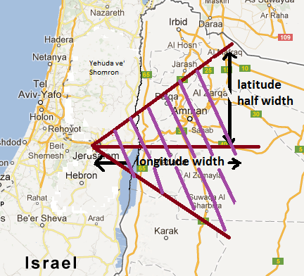
The calculation area, as shown in the figure above, is
defined by the “longitude width”, lon w (Step
“1h”), and the “latitude half width”, lat hw (Step “1g”). Typical values of “lon
w”, and “lat hw”
for ארץ
ישראל are: lon w = 1 degree, lat hw = 1 degree. Parameter Step “1f” determines how much of
the near terrain is ignored when calculating a table. For example, if it is equal to “0.5 km”, then
the nearest 0.5 km of terrain next to the selected place will be ignored, i.e.,
“shaved off” (ניכוי
הרים).
To avoid misuse of this feature, and following the פסק of Rav Elyashiv ז"ל, its magnitude is limited to approximate distance of תכום
שבת for Eretz Yisroel calculations.
Parameter Step "1i" determines whether the program returns an error
code if a DTM tile is missing. This can happen for two reasons: (1) missing
ocean tiles, (2) trying to calculate a table for a geographic region that is
not supported or is adjacent to such an area (i.e., outside North America,
England, and Eretz Yisroel.) If (1) is the reason for the error, then the
calculation can be repeated after checking the box.
When you finish calculating a place, the results are
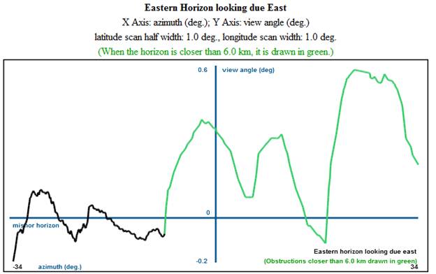
returned in the form of a graph, as shown below, and a table of זמנים.
The graph indicates places where the horizon is closer than 6 km by
drawing them in green. The plot is view
angle (i.e., what a surveyor measures using a theodolite) versus azimuth. For sunrise calculations, azimuth at due east
is defined to be equal to zero. For
sunset calculations, the azimuth at due west is defined to be equal to
zero. The “mishor
horizon” is also plotted whenever possible.
It corresponds to a fictitious horizon where everything in the distance
has the same height as the observer, i.e., the view angle is equal to
zero. The azimuth range used in the
calculation is marked on the horizontal axis (-34 to 34 degrees in the example
below). The view angle range is marked
on the vertical axis (-0.2 to 0.6 degrees in the example below). As a rule of thumb, each degree of “view
angle” corresponds to 5 minutes of delay in sunrise or sunset.