The Chai Tables
(last revised
7/4/2024)
I. Introduction
 Tables for sunrise are of course not a new thing.
The unique feature of the Chai Tables is they are the first
tables for North America and Europe to include visible sunrise
times (and visible sunset times of the USA). What does this mean, and why is this significant?
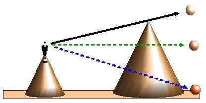
There are at least three ways to define the sunrise. The first
one is called the astronomical sunrise. It
corresponds to the time the sun appears to an observer at his
local height if all the mountainous obstructions in the horizon
are disregarded (blue arrow). The second type of sunrise is
called the mishor sunrise. It corresponds to
the time that the sun is seen rising over a flat horizon for an
observer at the height of the horizon (green arrow). This is
the sunrise that is published by the Naval Observatories and is
printed by the newspapers in the USA. The third type of sunrise
is the visible sunrise, corresponding to the time
that the sun is actually seen to rise over the true horizon (black
arrow). The definitions for sunset are the same (except the figure
is reflected about the observer).
Tables for sunrise are of course not a new thing.
The unique feature of the Chai Tables is they are the first
tables for North America and Europe to include visible sunrise
times (and visible sunset times of the USA). What does this mean, and why is this significant?
There are at least three ways to define the sunrise. The first
one is called the astronomical sunrise. It
corresponds to the time the sun appears to an observer at his
local height if all the mountainous obstructions in the horizon
are disregarded (blue arrow). The second type of sunrise is
called the mishor sunrise. It corresponds to
the time that the sun is seen rising over a flat horizon for an
observer at the height of the horizon (green arrow). This is
the sunrise that is published by the Naval Observatories and is
printed by the newspapers in the USA. The third type of sunrise
is the visible sunrise, corresponding to the time
that the sun is actually seen to rise over the true horizon (black
arrow). The definitions for sunset are the same (except the figure
is reflected about the observer).
Which is the proper sunrise to use for the purpose
of morning prayer? The gemorah Yerushalmi in
tractate Brochos (first chapter) states in the name of
Rebbi Zavdi in the name of Rebbi Yonah that sunrise (for purposes
of krias shma) is when the sun's rays begin to illuminate
the tops of the mountains. In the same place, the gemorah
relates how Rebbi Elazar ben Azaria and Rebbi Akiva waited to say
krias shma until the sun appeared on the top of the
mountains. The Bi'ur Halachah (Orach Chaim, chapter
58) explains that the gemorah is rendering the halachic
opinion that the time of sunrise for prayer purposes is when the
sun becomes visible on the horizon. The gemorah Bavli
in tractate Brochos (p. 7) describes how Hashem is angry
during one special moment of the day, i.e., at sunrise, when all
the kings of the nations bow down to the rising sun. Of course,
they bowed down to a visible sun.
The rabbis, of blessed memory, tell us in tractate Megillah
(page 20) that the miztvos that are done during the day,
are permitted to be done, a priori, only after the sunrise
even though the day begins at dawn. Rashi explains that this is
so we should have no doubt that the night has passed. The Ran
explains further that not everyone knows how to distinguish the
dawn from the night. We therefore wait until sunrise for only
then is it clear to everyone that the night has passed.
The Ran seems to imply that only when the sun is visible (i.e.,
after the visible sunrise) can there be no doubt
that night has passed. The Mishnah Brurah (in Section 588(2)
) seems to understand that this was the intention of the Ran .
The Mishnah Brurah, when discussing the proper time to
blow shofar, first brings down the Ran (above) and then
quotes the Pri Megodim that one doesn't have to wait to
blow shofar until the entire sun is visible, rather it is
sufficient to wait until only the very first part of the sun is
visible. Once again, the Mishnah Brurah seems to have
decided that the proper sunrise for mitzvos hayom purposes
is the visible sunrise. This is also in accordance with the mishnoh
in tractate Yumah (p. 37) which describes the nivreshes
that Queen Heleni contributed to the Beis Hamikdosh. The
nivreshes reflected the sun's rays at the moment of the
visible sunrise in order that everybody would know that the time
of krias shma had arrived. (Tosofos (ibid.) explains that
the vasikim were able to determine this time without the
help of the nivreshes, and therefore finished krias
shma right before the visible sunrise, at which time they
began the shmonah esray.)
However, the gemorah Bavli tractate
Pesachim (p. 93) states that the interval between sunset and
twilight is the same as the interval between dawn and sunrise.
This is clearly the astronomical sunrise (since the interval
between the visible sunrise and dawn is not necessary equal to
the interval between the sunset and twilight). In fact, this is
not a contradiction to the gemorahs we have brought above.
The gemorah in Pesachim is concerned with how one
calculate times of the day (shaos zemanios) for which one
uses the astronomical or mishor sunrise. However
the gemorahs we brought above were concerned with the
proper times for krias shma and shmonah esray. For
these purpose one must wait until the visible sunrise. Why is
that so? The Meiri on tractacte Brochos (p. 9 second side)
explains that the awareness of Hashem generated by the shmonah
esreh balances the lack of awareness of Hashem as displayed
by most nations. The Jewish people therefore accustomed
themselves to pray at the same time as those nations begin their
sun worship, i.e., at the moment that the sun became visible.
It is probably for the reasons given above that the
custom of Eretz Yisroel is to wait to start the shmonah
esreh until the moment of the visible sunrise, v'mezion
tezei torah. The purpose of these tables is to give this
option to other Jewish communities.
 In practice how
does one define the visible sunrise for cities built in valleys
and on tops of hills, as is the case of most cities in the world.
Usually the high places will see the sunrise before the places
built in valleys. Do all the people in the city use the sunrise
seen on the high places or does each one have his own visible
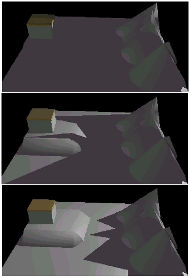
sunrise? As mentioned above, the mishnoh in Yumah (p.
37) describes how Queen Heleni contributed a golden menorah
("nivreshes") to the second Temple in order to
reflect the rays of the sun during the initial minutes of sunrise
(see the top figure on the right). The gemorah (ibid)
brings a breisoh stating that in this way everybody
in Jerusalem would know that the time for krias shma had
arrived. It is known that even in the second Temple era, most of
Jerusalem extended in the direction of the Kidron and Himnom
valleys. The city then extended from these places of low
elevation northward and westward to higher terrain. Not everyone
in Jerusalem would have seen the sunrise at this time. The
visible sunrise seen by the inhabitants of the lower portions of
Jerusalem for the summer months was at 15 minutes later than the
visible sunrise seen by the nivreshes if it was placed on
the top of the Temple as seems to be the opinion of the Tosofos
and the Ritvah (middle and bottom figures on the right).
Nevertheless there was only one sunrise time for the entire city,
and it was the earliest visible sunrise to be seen in the city.
This reflects the halochic principle that we don't make
divisions within one city ("ein osim agudos agudos bair
achas"). Another example of this is in the gemorah
Shabbos 118b which relates how Rebbi Yosi lauded all the
inhabitants of Tiberius for accepting Shabbos early.
This implies that they began Shabbos together otherwise he would
have lauded those that accepted the earliest Shabbos
time in the city. This is despite the fact that Tiberius is built
on the side of a mountain and the times of sunset varies greatly
between parts of the city. (These proofs for using the earliest
visible sunrise time for the entire city is brought in part by
the Tshuvos "Sifsei Yishainim", pp. 26-27, of Rav
Moshe Nehemiah Cohanav, a contemporary of Rav Yehoshuah Leib
Diskin.)
In practice how
does one define the visible sunrise for cities built in valleys
and on tops of hills, as is the case of most cities in the world.
Usually the high places will see the sunrise before the places
built in valleys. Do all the people in the city use the sunrise
seen on the high places or does each one have his own visible
sunrise? As mentioned above, the mishnoh in Yumah (p.
37) describes how Queen Heleni contributed a golden menorah
("nivreshes") to the second Temple in order to
reflect the rays of the sun during the initial minutes of sunrise
(see the top figure on the right). The gemorah (ibid)
brings a breisoh stating that in this way everybody
in Jerusalem would know that the time for krias shma had
arrived. It is known that even in the second Temple era, most of
Jerusalem extended in the direction of the Kidron and Himnom
valleys. The city then extended from these places of low
elevation northward and westward to higher terrain. Not everyone
in Jerusalem would have seen the sunrise at this time. The
visible sunrise seen by the inhabitants of the lower portions of
Jerusalem for the summer months was at 15 minutes later than the
visible sunrise seen by the nivreshes if it was placed on
the top of the Temple as seems to be the opinion of the Tosofos
and the Ritvah (middle and bottom figures on the right).
Nevertheless there was only one sunrise time for the entire city,
and it was the earliest visible sunrise to be seen in the city.
This reflects the halochic principle that we don't make
divisions within one city ("ein osim agudos agudos bair
achas"). Another example of this is in the gemorah
Shabbos 118b which relates how Rebbi Yosi lauded all the
inhabitants of Tiberius for accepting Shabbos early.
This implies that they began Shabbos together otherwise he would
have lauded those that accepted the earliest Shabbos
time in the city. This is despite the fact that Tiberius is built
on the side of a mountain and the times of sunset varies greatly
between parts of the city. (These proofs for using the earliest
visible sunrise time for the entire city is brought in part by
the Tshuvos "Sifsei Yishainim", pp. 26-27, of Rav
Moshe Nehemiah Cohanav, a contemporary of Rav Yehoshuah Leib
Diskin.)
The visible
sunrise is sometimes obscured by very local obstructions. In the
most absurd example, an individual in a deep ditch won't see the
sunrise until midday. It sometimes occurs that the sunrise
horizon for an entire city is obscured by local mountainous
obstructions. This was the case of Jerusalem in the late 1800's
when the entire population dwelled in what we know today as the
Old City. Their sunrise horizon was obstructed for half of the
year by Har Hazeisim which is a little more than one kilometer
from the eastern end of the Old City. The question of what one
does in such a situation was brought to Rav Yehoshuah Leib Diskin.
He rendered a pesak din (recorded in "HaNivreshes",
p. 58-59) that one certainly discounts very local mountains such
as Har Hazeisim, but one need not disregard distant
mountains such as the Moab mountains (which are between 40-70 km
from Jerusalem). However, no distance was given to define the
dividing line between close and far mountains. (It is also
unclear how Rav Yehoshuah Leib Diskin reconciled his pesak
with the sugiah of the nivreshes, which implies
that one does not discount Har Hazeisim. It is possible
that Rav Yehoshuah Leib Diskin felt that Har Hazeisim
could be ignored in calculating the sunrise times for the Old
City for the following reason. The sunrise times seen by the nivreshes,
if it was placed on top of the Temple, was probably not
significantly different from the sunrise times seen from Har
Hazeisim. Therefore any delay to the sunrise time caused by Har
Hazeisim, as seen by an observer on the ground,was due to
that observer's low elevation in comparison to the height of the nevreshes.)
In our tables for Eretz Yisroel (Bikurei YosefTables) we
therefore included all mountains in the horizon as permitted by
the accuracy of the Digital Terrain Model (DTM). We have followed
this procedure for the Chai Tables.
The use of one sunrise time for an entire city works
well for a city the size of Jerusalem. To this day, the poskim
of Jerusalem agree that all of Jerusalem (which extends about 16
km. north-south, and 15 km. east-west) abides by the earliest
sunrise time as seen from the highest places in Jerusalem. (The
first visible sunrise is generally not seen at the same place
every day, since the sunrise occurs over a different part of the
mountainous horizon on different days of the year.) However, how
is the sunrise defined for cities the size of New York, Chicago,
or Los Angeles where continuous habitation can extend for over
100 km or more! In such a case even the astronomical sunrise
differs by about 4 minutes from the most eastern to the most
western portion of continuous habitation in that area.
We say that that there must be one sunrise time for
the inhabitants of a small city since night and day cannot exist
simultaneously at any one small place. Furthermore, it is hard to
imagine that any slight change of observer height and effect of
local obstructions should change the sunrise time of the observer
in a significant manner. If that would be the case, then the sun
would never rise or set for someone indoors! Obviously, he must
open his windows and take a look. Similarly, he should go up to a
nearby high vantage point to observe an earlier sunrise. It is
necessary to say that there is no such thing as a local
visible sunrise for any small place. However, when night and day
does in fact exist simultaneously, in the case of a large city,
then certainly we are not restricted to one visible sunrise for
everybody.
 To our knowledge, this problem has not been dealt
with by the poskim. The Chai Tables attempt to solve this
problem as follows. For large cities, one must calculate visible
sunrises for sub-city areas. In general, a person is associated
with a sub-city area which is considered his local environment.
His synagogue is probably there, as well as the stores that he
frequents. This is his local city, neighborhood, or community.
The earliest sunrise time to be seen in that area would also be his
sunrise time. The gemorah Eruvin 60b infact
implies that the area of a city that a person frequents is
equivalent to his local environment. That gemorah states
in the name of Rebbi Yeshua Ben Levi that if a person's techum
of 2000 amos extends to the end of a city, then that city
is considered as only 4 amos long, and he can travel
another 1996 amos. Why did Chazal use the value of
4 amos? To tell us that a person's city is equivalent to
his own domain (which is of course 4 amos) since he makes
use of that area as though it was his own 4 amos.
Of course, in the case of sunrise, this area must be limited, as
explained above. For convenience, the Chai Tables define this
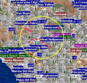
region as a circle about the observer. What would be the
dimensions of that circle? Since Jerusalem is considered as one
city even though it extends about 8 km. in each direction from
the city's center, then it is reasonable to use a radius of 8 km.
as the default radius of this circle (The Search Radius). The earliest
sunrise within this radius (which could be from different places
on different days as explained above) will thereby define the
sunrise for any person near the center of that circle. This
circle (yellow circle in the figure for the example of West
Hollywood, California, USA), of course, moves with the observer.
But the sunrise times for neighboring circles separated by
distances smaller than 8 km will be similar. This is because it
is unlikely that any new high vantage points (red spots in the
figure) will be included within these circles for small changes
in their center position. In this way, night and day will not
reign simultaneously in any one place. In fact, for cities
smaller than 16 km in diameter, all residents of the city will
have the same visible sunrise, as is case for Eretz Yisroel.
To our knowledge, this problem has not been dealt
with by the poskim. The Chai Tables attempt to solve this
problem as follows. For large cities, one must calculate visible
sunrises for sub-city areas. In general, a person is associated
with a sub-city area which is considered his local environment.
His synagogue is probably there, as well as the stores that he
frequents. This is his local city, neighborhood, or community.
The earliest sunrise time to be seen in that area would also be his
sunrise time. The gemorah Eruvin 60b infact
implies that the area of a city that a person frequents is
equivalent to his local environment. That gemorah states
in the name of Rebbi Yeshua Ben Levi that if a person's techum
of 2000 amos extends to the end of a city, then that city
is considered as only 4 amos long, and he can travel
another 1996 amos. Why did Chazal use the value of
4 amos? To tell us that a person's city is equivalent to
his own domain (which is of course 4 amos) since he makes
use of that area as though it was his own 4 amos.
Of course, in the case of sunrise, this area must be limited, as
explained above. For convenience, the Chai Tables define this
region as a circle about the observer. What would be the
dimensions of that circle? Since Jerusalem is considered as one
city even though it extends about 8 km. in each direction from
the city's center, then it is reasonable to use a radius of 8 km.
as the default radius of this circle (The Search Radius). The earliest
sunrise within this radius (which could be from different places
on different days as explained above) will thereby define the
sunrise for any person near the center of that circle. This
circle (yellow circle in the figure for the example of West
Hollywood, California, USA), of course, moves with the observer.
But the sunrise times for neighboring circles separated by
distances smaller than 8 km will be similar. This is because it
is unlikely that any new high vantage points (red spots in the
figure) will be included within these circles for small changes
in their center position. In this way, night and day will not
reign simultaneously in any one place. In fact, for cities
smaller than 16 km in diameter, all residents of the city will
have the same visible sunrise, as is case for Eretz Yisroel.
In many cases
after averaging over the possible vantage points within the radius
of influence, the calculated visible sunrise time will become
similar to the mishor sunrise. The only real difference
will be for truly high vantage points which will actually see
an earlier sunrise than the mishor sunrise, and for
those places with high mountains in the distance in all
directions. For the last case the visible sunrise can be
significantly later than the mishor sunrise.
If a city is nestled between
hills, the inclusion of vantage points near the hills can often degrade the
quality of the table (since these high vantage points are situated close to even
higher obstructions). Therefore in the event that a calculated table of the
visible times has many times marked in green (indicating near obstructions), one
can try to improve the quality of the table by reducing the "Search Radius".
II. The Visible
Sunset
In the gemorah Shabbos
118b ( as mentioned above) Rebbi Yosi lauded the inhabitants of Tiberias for
ushering in Shabbos when the sun sank over the visible horizon. Rashi
(ibid) implies that this was only a stringency. Rather, the true sunset
time for Tiberias was the time of sunset for Zippori, located on top of the
hill. We understand from Rashi that sunset is the time when the sun sets
for the high places within or adjoining the city. .Rebeinu Nisim (ibid)
seems to agree with Rashi and wrote further that the visible sunset of
Tiberius is a "siag" (fence), and those who accept it are praise worthy.
This is in fact brought down as the halocho by the Magen Avrohom and the
Beir Hetev in Orech Chaim, section 233. That is, the time of minhah
is "a priori" up to the time of the visible sunset . For these reasons,
Hagaon Rav Moshe Feinstein wrote in Egros Moshe (Orech Chaim Vol. I, responsa
97) that one should be stringent to accept a "siag" upon
themselves by ushering Shabbos before the time of the visible sunset over the
mountains.
Due to the availability in the
US of accurate DTM's, it is possible to provide visible sunset times for the
cities of the US. Even though the 30-m SRTM data is not reliable for many
urban areas (see below), the 30-m NED data can be used to obtain reasonably
reliable heights within the city. It is therefore possible to provide
reliable visible sunset times for much of the US. (The visible sunset times for
Eretz Yisroel are calculated using the 25-m DTM of Israel.) These times
should be used only as a siag, and only after consulting with a competent
halochic authority..
III. How
is the visible sunrise calculated for any observer
For any
city, likely vantage points that would contribute to the earliest
sunrise were searched for, and the horizon profiles for those
places were calculated and recorded. When you, the user of our
program, choose a set of coordinates, the subset of vantage
points within the chosen circle of influence is determined, and
the sunrise times for all these vantage points are calculated.
The earliest sunrise time that is seen (i.e., calculated) among
these vantage points determines the sunrise time for the observer.
(For details on the calculation of these profiles and their
sunrise times, see the paper of Keller, Hall that can be downloaded
from the "published papers" section of the Chai Table's
home page.)
IV.
Accuracy of Visible Sunrise Calculations
In the past, the
elevation model that is used for most of the Chai Tables is the
United States Geological Survey's (USGS) GTOPO30 Digital
Elevation Model of the world. The
GTOPO30 consists of an evenly spaced grid of interpolated
elevation readings approximately every kilometer. The topographic
data base that was the source of the GTOPO30 for the USA was the
30 meter topographic maps of the USGS. The source of the GTOPO30
for most of Eurasia, and large parts of Africa, South America,
Mexico, Canada, and Central America was the Digital Terrain
Elevation Data (DTED) Model produced by the USA's National
Imaging and Mapping Agency (NIMA). In these regions it is
expected that the GTOPO30 has an absolute vertical resolution of
30 meters, and a root mean square vertical accuracy of 18 meters.
The coarseness of this grid means that it is not very useful in
determining horizon profiles if there are obstructions within 30
kilometers. This holds true especially for relatively flat areas.
Due to this fact, very local obstructions (closer than 5 km to
any observation point) were not included in the calculations.
However, when many vantage points are averaged over the circle of
influence with a radius equal to 8 km., then inaccuracies of the
GTOPO30 should not cause more than a ½ minute error in the
sunrise times. This ½ minute inaccuracy was determined by
comparing their times to visible sunrise times calculated from
the USGS 100 meter Digital Elevation Model of the USA.
A preliminary version of the
Shuttle Radar Topography
Mission (SRTM) digital terrain model encompassing most of the world has
been released. For the USA, the data set consists of equally spaced heights approximately
every 30 meters (SRTM-Level 2, i.e., SRTM-2). The SRTM DTM data spacing
for the rest of the world is one elevation value for approximately every hundred meters (SRTM-Level 1, i.e., SRTM-1).
At present, almost all of the Chai tables have been recalculated using the SRTM.
A comparison
of the SRTM-1 elevations to known elevations in one location in Canada has shown
that the vertical resolution is (+/-) 6 meters, while horizontal (spatial)
resolution is excellent (B. Rabus, "First
experiences with validating SRTM X-band data over Canada"). This
compares favorably with the expected vertical resolution of (+/-)10 meters.
Therefore, the horizon profiles calculated from the SRTM-2 should be accurate to
approximately 20 sec. as long as obstructions
are further than 6 km. from the observer. Assuming an average distance to
obstructions of 20 km, the accuracy of SRTM-2 data will increase to
approximately 5 seconds. SRTM-1 data's horizon profiles will be accurate to 20
seconds for obstructions greater than 18 km. Therefore, only a 5 seconds
have been added to calculated times using SRTM-2 data. (Twenty
seconds will be added to calculations based on the SRTM-1 terrain model for
areas outside the US.) This cushion in combination with the 15 second
cushion added for atmospheric effects (see below) was deemed adequate to account
for better than 90% of any expected error.
Due to the
greater accuracy of the SRTM DTMs, only 1 km of near obstructions was ignored in
the calculations (versus 5 km for the GTOPO30).
Times that are as accurate or more accurate than the minimum expected accuracy
are printed in black.
Since sunrise times calculated
from SRTM data set can be highly accurate, it is appropriate to notify the user
when the calculation is in fact degraded due to close obstructions.
Therefore, times that are likely to be inaccurate due to close obstructions
(less than 6 km for the SRTM-1/2) are printed in green.
An unfortunate degradation of
SRTM accuracy occurs within urban areas having a high concentration of tall buildings (see the article
by Rabus, ibid.) This effect is especially noticeable in flat
regions of the world. In such cases, tall buildings dominate the
skyline (and therefore, the horizon profiles). The buildings appear as
spikes (glitches) whose shapes are dependent on the buildings and the distance
from the observation point. Tall building can erroneously increase the SRTM ground elevations
to more than 30 meters. If many points in the city contribute to the
sunrise time, then the glitches will be averaged out. However,
shorter buildings also add an ubiquitous elevation scatter of between 5-10
meters. I have overcome this problem in the USA by substituting the SRTM
heights in most urban areas with the 30 meter NED (National Elevation Data
Set) heights. In those cases, the SRTM data is only used for determining
the shape of the distant horizon. Unfortunately, there is no affordable
alternative to the SRTM for outside the USA.
A further source
of error for the Chai Tables, notwithstanding the DTM used for the calculations,
results from inaccuracies in the
modeling of the atmosphere. The atmospheric model I use is based
on modified mid-latitude "summer" and "winter"
atmospheric models used by the Lowtran 6 Computer Codes. For
tropical latitudes, I use the "summer" atmosphere for
the entire year. For latitudes above and below N 20 and S 20
degrees, respectively, I use a combination of "winter"
and "summer" atmospheres. The percentage of winter days
of the year are increased as a function of latitude in a stepwise
fashion. For example, in the Northern Hemisphere, all latitudes
between N 30 degrees and N 40 degrees are assumed to have a
similar summer to winter atmosphere ratio (1.28) as that of Eretz
Yisroel (which lies between latitudes of N 30 to N 33 degrees).
This ratio was determined from daily observations of the visible
sunrise at several places in Eretz Yisroel.
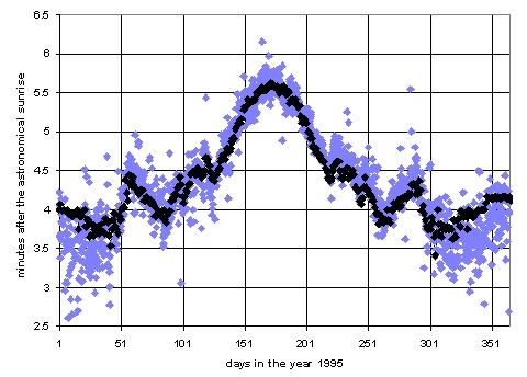 Comparison of actual sunrise observations done in
Jerusalem to calculated sunrise times have shown that sunrise
times can be calculated for distant horizons (farther than 20 km.)
to an accuracy of at least ¼ minutes for 90% of the time. (See
the figure on the right which is a plot of the visible sunrise
minus the astronomical sunrise for the Jerusalem neighborhood
Armon Hanatziv. Black dots are calculations, blue dots represent
10 years of observations by Rav Avraham Druk. For more
information see the paper by Keller and Hall) Since
those calculations used the 25 meter Digital Terrain Model (DTM)
of Eretz Yisorel, almost all the discrepancy
between calculation and observation was due to atmospheric
effects. Therefore, in the case of distant horizons, and for
latitudes close to those of Eretz Yisorel, the Chai Tables of visible sunrise times
should have a maximum accuracy
of ¼ minutes. Typically, the accuracy should be on the order of
the sum of the atmospheric inaccuracy (¼ minutes) and the
inaccuracy inherent in the SRTM (5 sec. for SRTM-2, 20 seconds for SRTM-1)
and in the GTOPO30 (½ minutes). I have
therefore added a cushion of ¾ minutes to all the calculated visible sunrise times calculated using the GTOPO30, a 20 second cushion to visible
sunrise times calculated in the USA using the SRTM-2, and a 35 sec. cushion to
visible sunrise times calculated using the SRTM-1 (for outside the USA). The
resultant times are rounded to the nearest later 5 seconds. (You can contact
us to verify that your sunrise horizon is determined
by far obstructions.)
Comparison of actual sunrise observations done in
Jerusalem to calculated sunrise times have shown that sunrise
times can be calculated for distant horizons (farther than 20 km.)
to an accuracy of at least ¼ minutes for 90% of the time. (See
the figure on the right which is a plot of the visible sunrise
minus the astronomical sunrise for the Jerusalem neighborhood
Armon Hanatziv. Black dots are calculations, blue dots represent
10 years of observations by Rav Avraham Druk. For more
information see the paper by Keller and Hall) Since
those calculations used the 25 meter Digital Terrain Model (DTM)
of Eretz Yisorel, almost all the discrepancy
between calculation and observation was due to atmospheric
effects. Therefore, in the case of distant horizons, and for
latitudes close to those of Eretz Yisorel, the Chai Tables of visible sunrise times
should have a maximum accuracy
of ¼ minutes. Typically, the accuracy should be on the order of
the sum of the atmospheric inaccuracy (¼ minutes) and the
inaccuracy inherent in the SRTM (5 sec. for SRTM-2, 20 seconds for SRTM-1)
and in the GTOPO30 (½ minutes). I have
therefore added a cushion of ¾ minutes to all the calculated visible sunrise times calculated using the GTOPO30, a 20 second cushion to visible
sunrise times calculated in the USA using the SRTM-2, and a 35 sec. cushion to
visible sunrise times calculated using the SRTM-1 (for outside the USA). The
resultant times are rounded to the nearest later 5 seconds. (You can contact
us to verify that your sunrise horizon is determined
by far obstructions.)
The almost exclusive source of
maps for my latest recalculation of the horizon profiles is
www.expedia.com. Expedia provide both
topographical and road maps. The former allows for relatively accurate (to
better than 1 km) placement of the city center. The latter allows for placement
of neighborhoods to better than 1 km.
The maps from Expedia seem to
be derived from NIMA's
GEOnet database coordinates. Please refer to Expedia's maps for
positions of the city centers and neighborhoods. If the user can
determine his center coordinates (e.g., by using GPS) then they
can be used instead of ours (see below).
V. How do you pick
your place?
In order to
maximize the user-friendliness of this program, I have provided
the names and coordinates of cities that have a significant
Jewish Orthodox presence and neighborhoods within these cities.
When the user picks one of these neighborhoods or sub-cities,
then the program uses the known coordinates of that neighborhood
or sub city as the center of the observer's circle of influence.
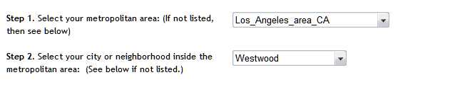
See below for the example of Westwood, Los Angeles area,
California, USA. If your metropolitan area is not listed, then
you will be only able to calculate mishor and astronomical times.
Since it is difficult to know the names of
all the neighborhoods where Orthodox Jews live, I usually list
all the sub-cities that are marked by the maps mentioned in
section III. If the Jewish neighborhoods are known, then they
have been listed even if they do not appear on the maps. (If
we have missed your neighborhood, let us know. Please help us make the Chai Tables more useful).
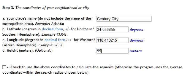
In the case that your metropolitan area is listed but your
neighborhood has been inadvertently skipped, or if you wish to pick an exact
place, then the "Chai Tables Geofinder" button should be used. This button
sends the user to a Google map interface. With this interface, an exact
place can be found. These coordinates will be used in calculating the
center of the search radius. If desired, the user
can input these coordinates by hand (although this is not recommended
since the sign convention for longitudes can be confusing). To use the "Geofinder"
(or to input the coordinates by hand) don't pick anything in "Step 2" (i.e.,
leave it displaying "Select a neighborhood").
Then press the "Geofinder" button (or input your coordinates) in Step 3 (see the figure below).
The
program uses the coordinates chosen with help of the "Geofinder" (or inputed by
hand) as the center of the
circle of influence and searches for vantage points within the
radius of the circle of influence. If no vantage points can be
found, the user can still calculate the astronomical and/or
mishor sunrise and sunset times for his place (the
astronomical and mishor sunset are defined like the
astronomical and mishor sunrise as described above).
(P.S., If we
have missed your Jewish Orthodox community please contact us by
filling out the feedback form).
It is the hope
of the author that these tables will help spread the proper
observance of the mitzvah of tefilas vasikin in the world.
VI.
Acknowledgments
The calculations
of these tables would not be possible without the generous help
of Professor John Hall of the Geological Survey of Israel who
provided the author with the computer hardware necessary for
these calculations .
A Short
Introduction to the Subject of "Zemanei Hayom"
The halochic day is divided into twelve
equal hours called "shaos zemanios". These hours
correspond to hours of a sun clock and therefore change their
length with respect to a mechanical clock during the course of
the year. These hours are used in calculating the permissable
times for many mitzvos. For example, "krias shma"
must be said before the end of the third hour, and morning prayer
must be completed before the end of the fourth hour. Even though
that the halochic day begins at dawn and ends at twilight, there
are several opinions concerning from when and to when the "shaos
zemanios" are counted. There are three major opinions.
The Opinion of the "Magen
Avrohom" (which is the opinion of the "Trumas
Hadeshen")
According to this opinion the "shaos
zemanios" are calculated by dividing the time interval
between dawn and twilight into 12 equal parts. There are also
many opinions on how to calculate dawn and twilight. However, the
amount of time between dawn and sunrise and between sunset and
twilight are equal (i.e., the time that it takes to walk
approximately four kilometers). Usually dawn/twilight is
calculated to be approximately 72 or 90 minutes before/after the
"mishor" sunrise/sunset. (Note that the 72 or 90
minutes are usually calculated in degrees of solar depresssion.
This results in 72 or 90 minutes for Eertz Yisroel during Nisan
and Tishrey.) Many people accept upon themselves the
stringencies of this opinion in relation to it's time for "sof
zman krias shma".
The Opinion of the "Groh"
(The Gaon of Vilna) (which is the opinion of the "Levush")
According to this opinion the "shaos
zemanios" are calculated by dividing the time interval
between sunrise and sunset into 12 equal parts. The sunrise and
sunset are taken to be the "astronomical" or "mishor"
sunirse and sunset (see above for the definition of "astronomical"
and "mishor" sunrise and sunset). Most ashkenazi
poskim consider this opinion to be the halochoh.
The Opinion of the "Ben
Ish Chai" (which is typically used by
Sephardic Jews)
According to this opinion the "shaos
zemanios" are calculated by dividing the time interval
between dawn and twilight into 12 equal parts. However the time
intervals between dawn and sunrise and between sunset and
twilight are not equal. This results in an unsymmetrical day. The
time interval between dawn and sunrise is larger than the time
interval between sunset and twilight. This is due to the fact
that the halochic twilight is the time after sunset for three
medium stars to appear. This is approximately 20-25 minutes in Eretz
Yisroel. However the civil dawn is approximately 90 to 72
minutes before the "mishor" sunrise.
One must consult a competent
halochic authority concerning which opinion to practice.